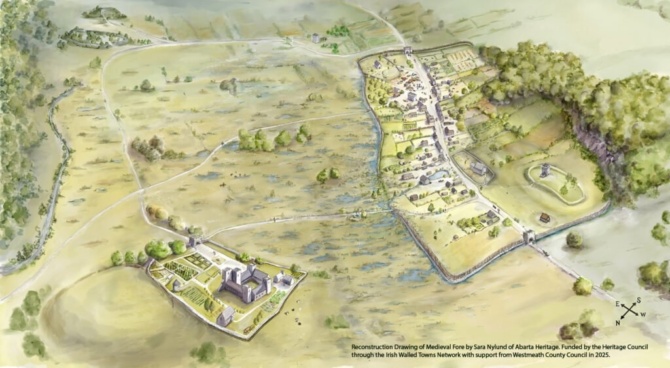
Reconstruction and Interpretation Drawing of Medieval Fore
- Co. An Iarmhí
This artist's interpretation of Fore in medieval times is based on the evidence available to date. It shows the town of Fore enclosed by earthen banks topped with wooden palisade fences. At either end of the main street are the stone gate entrances (which still survive today at the east and western ends of the village). To the north of the town lies the Benedictine Priory with Knocknamonaster behind. The motte and Bailey can be seen to the northeast of the town.
The reconstruction drawing was created by Sara Nylund of Abarta Heritage as part of an Interpretation Project for Fore that has been funded by the Heritage Council through the Irish Walled Towns Network with support from Westmeath County Council in 2025.
Discover the Wonders of Fore with an audio guide:
Fore has a rich history and heritage. Its ruins include the remains of two medieval parish churches, an anchorites’ (or hermits’) cell, three holy wells, the site of a motte and bailey castle, a medieval gaol, wayside crosses and one of the most impressive Benedictine Priories in Ireland. It was also a walled town, and two medieval gatehouses that once controlled access survive to this day.
Tune in to the Audio Guide linked below to hear more.
Audio guide created by Abarta Heritage in 2025, funded by the Heritage Council though the Irish Walled towns Network with support from Westmeath County Council.